This week, rather than diving into a unique subject heading from the Lester Levy Sheet Music Collection, I decided to share a teaser for an upcoming map project.
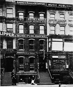
Before Times Square and Harlem were the centers of entertainment in New York City, Manhattan had at least two other major entertainment districts. One was Union Square (14th street and Broadway), followed by 28th street at Fifth Avenue, where sheet music production exploded in the early 20th century. Between 1880 and 1940, the music industry slowly migrated North from Union Square to Times Square, encouraged by improvements to infrastructure and transportation. The latter half of this era also saw the Harlem Renaissance bring new venues to the city and performers like Eubie Blake and Ethel Waters to the stage. The term “Tin Pan Alley” first refers to 28th street, where at least a dozen publishers set up shop directly next to each other (the origin of the name has been attributed to the collective sound of tinny upright pianos used to compose and market the songs). “Tin Pan Alley” also refers to the general movement of migration and productivity that churned out millions of copies of sheet music, where they were advertised by song pluggers and crooned from vaudeville stages. The end of the era is typically attributed to the rise and dominance of radio, the implementation of Prohibition, and the eventual Great Depression.

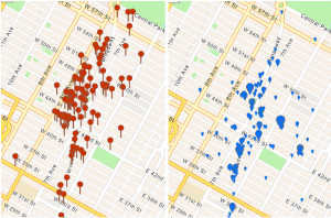
This period of music history has been the focus of intense research and investigation into the factors that motivated the migration of not only publishers and venues, but department stores and restaurants. The Levy Collection contains roughly 6,000 songs published in Manhattan during this time period, making it an ideal source of data to begin mapping this movement. Using ArcGIS Pro software, I have located and mapped the addresses for each publisher in Manhattan, as well as venues that operated between 1880 and 1940. I also added transportation networks, including the subway system and preceding elevated rail.

The result of this project will be a web application that allows users to explore Manhattan through time to visualize this migration. The size of each publisher’s map-marker will be determined by the number of songs they released that year, allowing users to watch the rise and fall of small and large publishers alike. This will also be a “living” project—layers can continue to be added that add more context to the map, including the locations of major department stores (such as Macys), speakeasies, and museums. Researchers will also have access to the raw data, allowing them to customize the map. Stayed tuned for more info!
