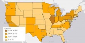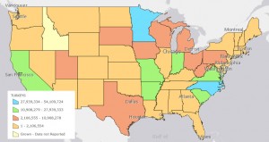
If you’re soon to be headed “over the river and through the woods” one question you’ll likely ponder along the way is where does Thanksgiving come from? No, not the history of the holiday, but rather the source of the food on our holiday dinner table. Geographic information systems (GIS) have become an invaluable tool for mapping authoritative statistics and one of our Sheridan Libraries fall guests recently updated her Thanksgiving food map story.

Who would have guessed that Illinois is number one when it comes to pumpkins and that Minnesota is trying hard to beat out North Carolina as the nation’s turkey capital? Counting farms, planted acres, harvested volumes, and farm workers originated back in 1820 with the decennial census. Over time the statistical gathering of crop and livestock numbers grew into our federal government’s Census of Agriculture. Now published every year ending in 2 and 7, the latest Ag Census data is widely accessible for download, and GIS map making, via the Internet.
Keeping statistics up to date is always a challenge. In light of the recent bouts of Avian Flu that struck turkey growers, mappers might need to supplement the Census of Agriculture with survey data issued by the National Agricultural Statistical Service (NASS). For agriculture, the survey data doesn’t usually include geographic areas down to the county level. However, it offers more recent numbers for the biggest producing states.
For a full holiday plate, including dessert, check out librarian Linda’s Zellmer’s Thanksgiving Maps & Posters. Johns Hopkins users can work with the Thanksgiving dinner data (see maps above) via their ArcGIS desktop software or ArcGIS Online for Johns Hopkins. Happy Thanksgiving!
